UNESCO – Kenya
Two years after the worst drought in 60 years hit the Horn of Africa, water remains a precious, illusive resource. This media project illustrates the story of UNESCO’s quest to find underground water in Turkana…
Two years after the worst drought in 60 years hit the Horn of Africa, water remains a precious, illusive resource. In Turkana, in northeastern Kenya, water scarcity continues to undermine food security and basic hygiene, with hundreds of thousands of people still vulnerable to malnutrition and disease.
Recognising the potential of a new geospatial technology being used by UNESCO in the region, the Government of Kenya called upon this specialized science and technology agency of the UN to carry out a survey of the region’s groundwater.
Conducted from July 2012 to February 2013 in northern and central Turkana County, the UNESCO study was the first of its kind in Kenya to utilize the advanced WATEX System developed by Radar Technologies International (RTI), which is recognised for its unique ability to accurately locate water in dry areas.
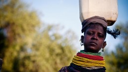
This media project illustrates the story of UNESCO’s quest to find underground water in Turkana. Arete produced a short film – which UNESCO has used to show what Gridmapping is about. A series of photographs were taken that has been used for internal and external marketting purposes. A multi media piece was produced that was given to the International Media; and a photographic exhibition was produced that is to be exhibited in both Nairobi and New York.
ClientUNESCOServicesVideo production and photographyYear2011-12Linken.unesco.org
Share